By MARY GREENE
MAMAKATING — Anyone who has driven south on Route 17 has
noticed the stretch of pancake-flat, marshy country lying just over the
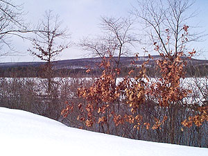
Wurtsboro Mountain. Here lies the Basha Kill wetlands, a wondrously unique
ecosystem born of glacial debris and the runoff of two mountain ranges.
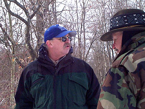
On a chilly but pleasant February morning, nine people
joined naturalist Gary Keeton for a guided tour into the winter wetlands. Most
of those present were members of the Basha Kill Area Association (BKAA), a
grass roots organization founded in 1972 and dedicated to preserving the beauty
of the area, promoting education and protecting the region from “ecological
degradation.” Keeton, a BKAA board member trained in forestry meteorology,
explained how the 2100-acre region formed as we strolled along a road that cut
through the wetlands.
“The Basha Kill began as a glacial lake, formed by glacial
debris and gravel washing over the valley from the Pine Kill [a stream that
flows into the Basha Kill]. During years when no major flooding occurred,
channels were formed. During times when it flooded, the waters would fill the
region.” Keeton pointed to evidence of old beaches in the form of knolls and
sand pits.
“In 1834,” he said, “a survey was conducted,” related to the
black dirt that exists under the wetland. A plan was formed to drain the area,
and 500 acres were lost to draining. This acreage was farmed through the 1880’s
until the advent of the railroad, when vegetables became harder to market
locally. A hurricane in 1938 plugged up the channel. The Army Corps of
Engineers unplugged it so farming could continue. But when several more strong
hurricanes caused the channel to become plugged again, efforts to unplug it
were abandoned. The region was claimed in the early 1970’s by the New York Department
of Environmental Conservation (DEC) as a wildlife management area.
Because of its unique placement, the Basha Kill is home to a
number of rare plants and fish. It also provides a home or migration corridor
for over 200 bird species. The limestone makeup of the Shawangunk Ridge on the
eastern side, and the more acidic soil of the Catskills to the west, make the
area compatible to the blue-spotted sunfish, found in only four places in the
state, and the bow fin, an ancient order of fish. There are rare salamanders in
the Basha Kill, as well as snapping turtles, painted turtles and other reptiles
and amphibians. The channel is, on average, two and a half feet deep, although
Keeton has measured it as deep as 30 feet in places. Much like a river channel,
the bog channel meanders through the area and can change its location over
time.
Keeton, who has served as a BKAA interpretive naturalist
since the mid-1980’s, pointed out signs of wildlife on the journey, including a
hawk (being chased out of crow territory by loudly cawing crows), wild turkey
tracks, coyote tracks and squirrel tracks. At one point, hikers stopped to
explore one of the many wood duck boxes that have been installed in the wetland
and surrounding woods by the DEC. The box had fallen from the tree. As Keeton
turned it over to show us its construction, two very startled squirrels leaped
out from under its leaves. Keeton apologized to the two silvery squatters, who
dashed away beneath the trees, and we moved on.
Keeton is knowledgeable about the history of the region as
well as its wildlife, pointing out the remains of old gravel pits. Gravel,
prevalent in the region, was mined to line the D&H canal beds. He also
pointed out an early traveler’s spring. The locations of these springs were
remembered by early travelers for, as ground water, they never freeze.
Reference to them appears frequently in letters and other records from early
settlers. Some of the springs, said Keeton, were renowned for the sweet taste
of their water, caused by their limestone linings. Weary sojourners would pass
many a drinking source to reach their special spring.
The BKAA organizes a number of hikes during the year,
“depending on what folks want,” said Keeton. Included among tits offerings are
full moon hikes, sunrise hikes and star gazes, as well as nature walks during
all four seasons.
Kelly Sheridan Crawford is a retired professional gardener
who joined the BKAA a year or so ago. She is also a member of a birding club
which visits the Basha Kill. “I love it,” she said. “It has so many varieties
of birds. I get to hike and watch birds all the time now.”
Robert Fiore, a BKAA board member, was along on the walk
with his son, Matt, 16. “The BKAA is a nice organization for families,” he
said. “It gets the children outside into nature.”
“The geology of this area is phenomenal,” continued Fiore.
“It goes back to Devonian period and the age of fish.”
Matt shared that he was a fossil collector. Where does he
find fossils? “All over,” he said. “In my driveway. Behind my house. Everywhere.”
For information on how to become a BKAA member or to learn
more about walks in the Basha Kill, write PO Box 1121, Wurtsboro, NY, 12790, or
call Florence Rothauser at 845/888-4361.